Panoramic Tour Bärenbader Jöchl

Hiking route recommended route

Panoramic Tour Bärenbader Jöchl

Hiking route · Hall-Wattens
Logo Tourismusverband Region Hall-Wattens
Responsible for this content
Tourismusverband Region Hall-Wattens Verified partner  Explorers Choice 
  • Photo: Anne W., Tourismusverband Region Hall-Wattens
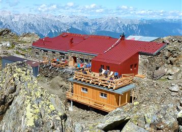
On the Schützensteig to the Bärenbader Jöchl
moderate
Distance 4.5 km
2:00 h
234 m
234 m
2,289 m
2,054 m
Profile picture of Anne W.
Author
Anne W. 
Update: September 29, 2023
Difficulty
moderate
Technique
Stamina
Experience
Landscape
Highest point
2,289 m
Lowest point
2,054 m
Best time of year
Jan
Feb
Mar
Apr
May
Jun
Jul
Aug
Sep
Oct
Nov
Dec

Track types

Dirt road 5.20%Path 79.03%Unknown 15.76%
Dirt road
0.2 km
Path
3.6 km
Unknown
0.7 km
Show elevation profile

Start

Tulfeinalm (2,055 m)
Coordinates:
DD
47.225954, 11.529559
DMS
47°13'33.4"N 11°31'46.4"E
UTM
32T 691494 5233378
w3w 
///compounded.anteater.scope

Destination

Tulfeinalm

Public transport

Public-transport-friendly

Bus 450 - Tulfes Glungezerbahn

By road

Tulfes

Parking

Tulfes - Glungezerbahn

Coordinates

DD
47.225954, 11.529559
DMS
47°13'33.4"N 11°31'46.4"E
UTM
32T 691494 5233378
w3w 
///compounded.anteater.scope
Arrival by train, car, foot or bike

Similar routes nearby

  • Von der Tulfeinalm auf den Schartenkogel
  • Viggarspitze
  • Die Neunerspitz` Runde
  • The Stone Pine Path
  • Haneburger
 These suggestions were generated by our system
Difficulty
moderate
Distance
4.5 km
Duration
2:00 h
Ascent
234 m
Descent
234 m
Highest point
2,289 m
Lowest point
2,054 m
Public-transport-friendly Out and back Scenic Refreshment stops available Family-friendly Flora Fauna Cableway ascent/descent Insider tip

Statistics

  • Content
  • Show images Hide images
Features
Maps and trails
Distance  km
Duration : h
Ascent  m
Descent  m
Highest point  m
Lowest point  m
Push the arrows to change the view

Please wait

Accommodation is searched

Please be patient for a little more time

All data will be loaded in an instant